Historical maps and photos of Mount Prospect Park, surrounding area and Brooklyn

Here's the source of the photos, captions, and more photos:
Comments
-
interesting!
-
I go there often and I never knew. Great find!
-
That's weird. I was just thinking about this place earlier today. It's the 2nd highest point in Brooklyn, after a part of Greenwood Cemetery. It was also used as a lookout point during the Revolutionary War. The Battle of Long Island occurred not far away.
-
Thanks for this. Very interesting.
-
Thank you for sharing!
-
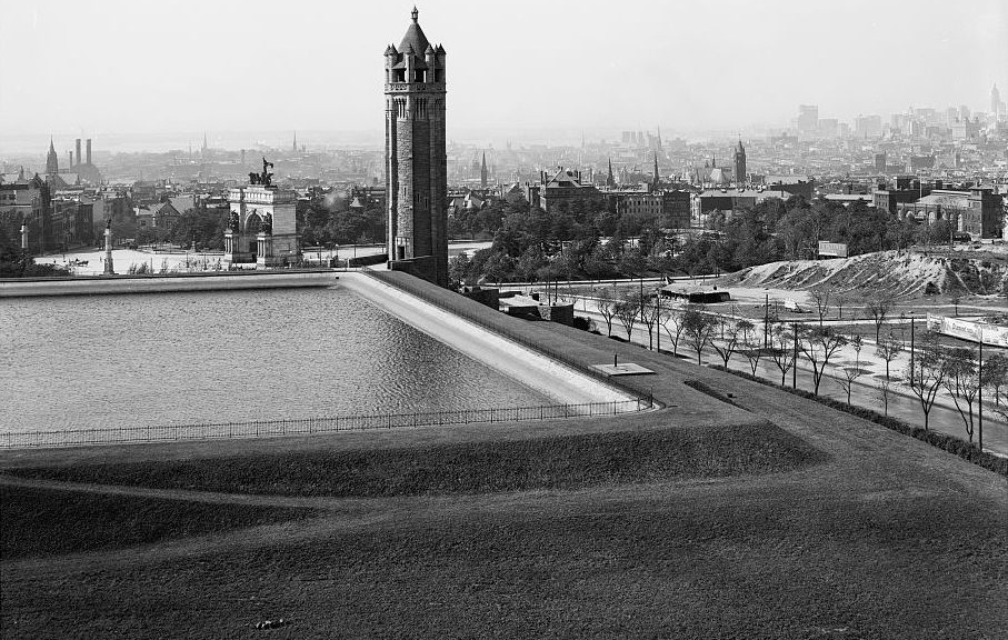
Next time you're up there, note the tall retaining wall that separates the park from the Library's lot (northwest corner of the park - alongside the stairs from Eastern Parkway).
That wall appears to be the last remnant of the reservoir / tower - it has a "waves" motif running along its top edge. -
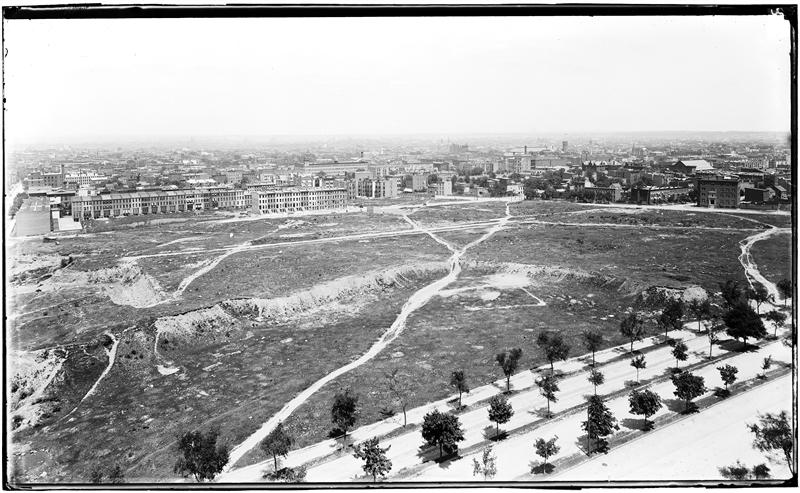
In addition to the pictures of the reservoir itself, I enjoyed the last pic. Apparantly it overlooks EP and the area north of it. That is some pretty big space and I am not sure if it is just a sort of wasteland, or just land waiting to be build on.
-
Was there ever a building at 1 Grand Army Plaza before the new current one, or was that lot always vacant?It is remarkable how the city just ended in the past, going from dense urban neighborhood to scrubland in the space of a block, whereas nowadays every city has miles and miles of suburban tract homes at the edge before getting to farm fields and unbuilt land.
-
The scrubland there was kind of in the middle of the newly-built neighborhoods all around it. I've seen this photo before and wondered about it. There must have been some reason this tract took longer to fill out into subdivisions.
-
I suppose it is Washington ave running from the very right side of the pic towards the center.
There is a very large building in the middle of the picture. It looks like it could be situated on the next avenue over from Washington. Anyone know what is? -
I can't tell you why the area by GAP didn't fill in until later, but these fire insurance maps from the NYPL show that it didn't. They generally show what is now Crown Heights filling in from Atlantic Ave south.
1899: http://maps.nypl.org/warper/layers/866
1906: http://maps.nypl.org/warper/layers/1057
There were a few bulidings between St. John's and Lincoln and one between Lincoln and E.P. by 1916 though: http://maps.nypl.org/warper/layers/1076
@Davina: Is it the Knox Hat Factory, still at Grand/St. Marks? (https://www.google.com/maps/@40.677433,-73.962502,3a,90y,105.33h,109.93t/data=!3m4!1e1!3m2!1stGmMZGZgh724BgD1ThkWWA!2e0) That building takes up a lot of the block and has a tower at the corner -- and the cornerstone says it was built in 1890 (and the maps confirm)
It is really interesting that Underhill doesn't seem to go through all the way to Eastern Parkway (though it is mapped)...
-
Perhaps this property was still owned by the city which was sitting on it for some reason?
-
 Looks like the city owned that land as part of the Prospect Park plan in 1870, and didn't get around to selling it for a good long time. They platted the part where the Botantical Garden is, but put the garden there instead I guess.
 -
That map predates the museum....and includes a traffic circle at Washington and EP.View today: http://goo.gl/maps/MzyWF
-
Yeah, the original plan had been for the land that currently comprises the library, Botanic Garden, and Mt. Prospect Park to be part of Prospect Park, but they ultimately decided they didn't want Flatbush Ave. to bisect the park.
-
Knox hat factory, interesting. What is that now - residential building?
So according to the 1870 map, Underhill does not extend all the way down to EP, reflecting the pics. I thought that it was just because of the angle on the picture that I could not see Underhill go all the way down to EP. -
Knox hat factory, interesting. What is that now - residential building?
Yes, it is subsidized housingHere's a cropped section of the map, so people can have an easier time seeing that Underhill didn't make it to EP. The road that is now Lincoln (which we should probably imagine as resembling something a little larger than a path, split just before what is now Bar Sepia. I went 90 degrees left until it connected with EP and went 45 degrees right until it connected with what is now St. Johns. modern day aerial shot: http://goo.gl/maps/lrYmc
 -
Readers may also enjoy this old aerial view of Brooklyn: http://www.old-maps.com/NY/ny-birdseye/0_NYC/Brooklyn_1897_DailyEagle_web2m.jpg
I didn't embed it because Brooklynian loses the details that make it interesting. Click on the map to further enlarge it. -
This new program showing how the geography of NYC changed over time is pretty cool
http://timemachine.vestigesofnewyork.com/ -
Cool stuff. I noticed that in 1893 Malbone is instead called Walbone (which later became Empire Blvd. after the Malbone St. Wreck some years later). Of course, Lincoln is also labeled Licoln, so it's also possible that whoever made this particular map was just a lousy speller.
-
Thank you for sharing!
Enjoying looking at what looks like farmland in both in Manhattan and Brooklyn in the 1700s, and the name "Brookland" in 1766.
-
A historical map of Prospect Heights: http://digitalcollections.nypl.org/items/510d47e2-0aeb-a3d9-e040-e00a18064a99
Lots of historical photos released on this new site: http://www.oldnyc.org -
mcpoet said:That's weird. I was just thinking about this place earlier today. It's the 2nd highest point in Brooklyn, after a part of Greenwood Cemetery. It was also used as a lookout point during the Revolutionary War. The Battle of Long Island occurred not far away.
Look Out Hill, Prospect Park: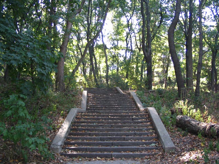
-
GAP in foreground, Mount Prospect behind.

-
Even back then, people didn't know how to navigate the circle.
-
Clearly, more white lines are needed.


Howdy, Stranger!
Categories
- 40K All Categories
- 27.1K Neighborhoods
- 5.1K Crown Heights/Prospect Lefferts Gardens
- 7.1K Prospect Heights
- 2.3K Fort Greene, Clinton Hill, Bed-Stuy
- 8K Park Slope
- 549 Williamsburg, Greenpoint, Bushwick
- 442 Flatbush/Midwood/Ditmas Park
- 657 BoCoCa (Boerum Hill, Cobble Hill, Carroll Gardens)
- 151 Red Hook
- 104 Gowanus
- 304 Bay Ridge/Bensonhurst
- 130 Coney Island, Brighton Beach, Sheepshead Bay
- 270 Brooklyn Heights, DUMBO and Downtown
- 598 Windsor Terrace / Kensington
- 673 Greenwood Heights and Sunset Park
- 749 Brooklyn and Beyond
- 6.3K Stuff
- 86 Brooklyn Back When
- 1.2K Brooklyn Pets
- 257 Brooklyn Kids
- 241 Brooklyn Eats
- 51 Brooklyn Booze
- 3.6K The Lounge / Random Stuff
- 611 Brooklyn Politics
- 122 Brooklyn Sports and Fitness
- 111 Brooklyn Photos
- 339 Site Issues
- 8 Frequently Asked Questions (FAQ)
- 6.2K Listings
- 1.1K APARTMENTS and REAL ESTATE
- 1.3K Sales Openings Events
- 2.3K The Classifieds